

The Gateway to the Colorado Plateau
In arid regions, water is the most critical natural resource. Isolated by the harsh surrounding landscape, springs are ecologically vital islands of habitat that support high biodiversity and endemism. In spite of the critical nature of water, aridland springs are inadequately protected, poorly mapped, and insufficiently understood. What limited information exists is largely unavailable to land managers who are charged with their protection.
Arizona, America’s second-driest state, likely contains the highest concentration of springs. The number of springs is unknown, as hundreds or likely thousands remain unmapped. Although several point feature layers exist for the state, none are complete and each contains features not included in the others. This map displays a compilation of springs location data provided by numerous sources, including land managers, Tribal governments, conservation organizations, and individual researchers. An interactive map of publicly available Arizona Springs information is available at ArcGIS Online.
Completed Projects
Coconino National Forest

Springs of Arizona are significantly clustered. This pattern is particularly pronounced along the Mogollon Rim - a spectacular escarpment that extends nearly 200 miles across central Arizona and defines the southwestern boundary of the Colorado Plateau. Much of Coconino National Forest straddles this ecotone, a mixing zone of tropical and boreal biota over recent geologic time.
With support from the Nina Mason Pulliam Charitable Trust, Grand Canyon Wildlands Council surveyed many springs in Coconino National Forest in 2009 and 2010. Grand Canyon Trust surveyed additional springs through their volunteer program, and shared their data for compilation at Springs Online. From 2011 to 2013, Northern Arizona University completed additional surveys with funding from the Nina Mason Pulliam Charitable Trust. Thanks to these efforts, and many volunteers, we have full survey data for 114 of the 369 known springs within this area. Through our partnership with Esri, SSI has developed an online, interactive map depicting springs across Coconino National Forest.
North Kaibab Ranger District
The North Kaibab Ranger District of the Kaibab National Forest covers over 1,000 square miles of rugged terrain on the north rim of the Grand Canyon. With much of its era designated as "Wilderness," this is a diverse and extraordinarily beautiful landscape. The steep desert canyons deeply incise high forests of the Colorado Plateau, creating more than 1300 meters of topographic relief.
The Grand Canyon Wildlands Council began surveying springs in this area in 2000. using an early version of protocols developed by Dr. Stevens and Dr. Springer. In 2009 and 2010, Grand Canyon Trust surveyed springs in this landscape using similar methods. Both organizations contributed their data, which we compiled in the Springs Online database. Since 2011, SSI has surveyed an additional 30 springs, which volunteers from Northern Arizona University, Penn State University, the University of Nevada Las Vegas, Grand Canyon Wildlands Council, Grand Canyon Trust, the Navajo Nation, and the Hopi Tribe.
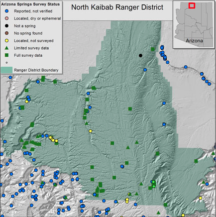
Compilation of available data for springs of the North Kaibab Ranger District. Data provided by ALRIS, Kaibab National Forest, Bryan Brown and Susan Moran, Glenn Rink, Grand Canyon Wildlands Council, and Grand Canyon Trust (click to enlarge).
Application of Springs Ecosystem Assessment:
Between 2011 and 2013, with support from the Nina Mason Pulliam Charitable Trust, an interdisciplinary team consisting of professionals and volunteers from Northern Arizona University, the Springs Stewardship Institute, the Grand Canyon Trust, and the Grand Canyon Wildlands Council, conducted springs ecosystems assessments (SEAP) on 200 springs across Coconino National Forest (CNF) and North Kaibab Ranger District (KNF).
Forest Service personnel supplied the research team with priorities pertaining to certain characteristics, which should be considered when assessing springs ecosystems. The criteria, determined by the forest managers, were used to select the top quartile of the springs in the study for increased stewardship. Stewardship plans for the selected springs were developed by the team as for the land and resource managers of CNF and KNF.
The information from the project was disseminated to the land and resource managers, various stakeholders, as well as the public, all in an effort to promote increased stewardship of springs ecosystems. The team formed in this project will continue to work with the Forest Service to seek future opportunities (i.e. the Four Forests Restoration Initiative and the Flagstaff Watershed Protection Program) to address the prioritized stewardship actions for springs in the region. An interactive mapping application is available at ArcGIS Online.
Williams District

Under contract with Kaibab National Forest, SSI surveyed 25 of the 80 known springs in the Williams District from 2011 to 2013.
Northern Arizona University also completed additional surveys with funding from the Nina Mason Pulliam Charitable Trust during this time. Thanks to these efforts, and many volunteers, we have survey data for 58 springs within the district.
View the interactive map of Coconino National Forest, available through ArcGIS Online. A username and password are required, but easily obtained. For more information, please contact us.
Apache-Sitgreaves National Forest

Springs mapped within the Wallow Fire perimeter.
In 2010, the Grand Canyon Wildlands Council conducted surveys of springs on the Mogollon Rim with the assistance of funding from the Nina Mason Pulliam Charitable Trust. Many of these springs were within the Apache Sitgreaves National Forest in eastern Arizona where many springs are clustered. On May 29, 2011, an unattended campfire sparked a wildfire that burned more than 850 square miles of forest land. Read more about the Forest Fire.
The fire undoubtedly affected the 557 known springs within the fire perimeter. Unfortunately, SSI was only able to survey a handful of springs within this area.
Arizona Strip
Where is it?
The Arizona Strip lies north of the Colorado River and is separated from the rest of Arizona by the Grand Canyon. The strip stretches for more than 7,800 square miles between Grand Canyon and the Utah border. The arid landscape is punctuated by iconic red rock canyons and sandstone formations such as the Vermilion Cliffs, the Wave, and water ways such as the Virgin River. The Springs Stewardship Institute, in partnership with the Grand Canyon Wildlands Council, has been a forward leader in helping to protecting and restoring springs and riparian habitats, as well as urging the federal government to establish the Grand Canyon Watershed as a National Monument.

Dr. Larry Stevens and students of Prescott College conducting restoration work at Leopard Frog Marsh as part of an ongoing rehabilitation project with the Grand Canyon Wildlands Council.
Grand Canyon Wildlands Council
The Grand Canyon Wildlands Council has partnered with the National Park Service as well as with the Springs Stewardship Institute to restore and manage springs and riparian habitats in Glen Canyon National Recreation Area. SSI has conducted a large rehabilitation effort with GCWC and students from Prescott College at Leopard Frog Marsh, a site with unique geomorphology and endemic species.
SSI has surveyed 105 springs in the Arizona Strip through partnership with GCWC. In addition to Leopard Frog Marsh, SSI has experienced tremendous success with Pakoon Spring. Restoration began in 2007 and the spring has had a very successful come back. Find out more about GCWC and its projects here.